


maps mit Streckendarstellung
-
@bahnuhr sagte in maps mit Streckendarstellung:
fitbounds.
weiß nicht, ob du das mal testen willst
habe mal in chatgpt eingegeben (aber nicht getestet):
was ist fitbounds in der leaflet bibliothek
und anschliessend :
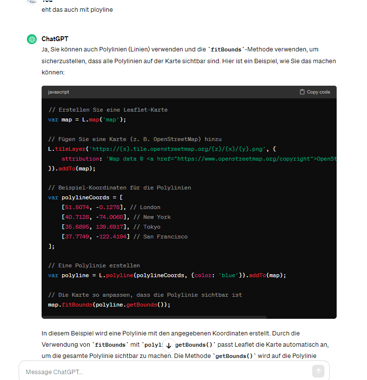
geht das auch mit polyline
vielleicht findest du da was brauchbares
ich brauche es ja mit circles, da mir die punkte als route besser gefallen - mal sehen, wann ich zum testen komme
@liv-in-sky sagte in maps mit Streckendarstellung:
leaflet
leaflet hatte ich hinbekommen.
Was nicht geklappt hatte war das ganze bei google maps.Hab ich aber jetzt auch hinbekommen.
Danke dir trotzdem.
Stelle code mit google maps dann mal ein.
Wenn ich helfen konnte, dann Daumen hoch (Pfeil nach oben)!
Danke.
gute Forenbeiträge: https://forum.iobroker.net/topic/51555/hinweise-f%C3%BCr-gute-forenbeitr%C3%A4ge
ScreenToGif :https://www.screentogif.com/downloads.html -
@liv-in-sky sagte in maps mit Streckendarstellung:
leaflet
leaflet hatte ich hinbekommen.
Was nicht geklappt hatte war das ganze bei google maps.Hab ich aber jetzt auch hinbekommen.
Danke dir trotzdem.
Stelle code mit google maps dann mal ein.
@bahnuhr sagte in maps mit Streckendarstellung:
Stelle code mit google maps dann mal ein
das wäre super - braucht man da ein google login ?
nach einem gelösten Thread wäre es sinnvoll dies in der Überschrift des ersten Posts einzutragen [gelöst]-... Bitte benutzt das Voting rechts unten im Beitrag wenn er euch geholfen hat. Forum-Tools: PicPick https://picpick.app/en/download/ und ScreenToGif https://www.screentogif.com/downloads.html
-
@bahnuhr sagte in maps mit Streckendarstellung:
Stelle code mit google maps dann mal ein
das wäre super - braucht man da ein google login ?
@liv-in-sky sagte in maps mit Streckendarstellung:
google login ?
ja, google key brauchst du.
Ohne klappt es nicht.
Wenn ich helfen konnte, dann Daumen hoch (Pfeil nach oben)!
Danke.
gute Forenbeiträge: https://forum.iobroker.net/topic/51555/hinweise-f%C3%BCr-gute-forenbeitr%C3%A4ge
ScreenToGif :https://www.screentogif.com/downloads.html -
@liv-in-sky sagte in maps mit Streckendarstellung:
google login ?
ja, google key brauchst du.
Ohne klappt es nicht.ich hasse das bei google - macht alles so mega komplex
-
@liv-in-sky sagte in maps mit Streckendarstellung:
google login ?
ja, google key brauchst du.
Ohne klappt es nicht.langsam nimmt es form an - paar kleinigkeiten sind noch zu machen - danke für das animieren und einstellen deiner scripte- hätte sonst wohl nicht damit begonnen
rot: blitzer
grün : wo bin ich gerade
schwarz: die tour
plus die temperatur für winter(glatteis)alles online verfolgbar (traccar) - lasse mir das u.a. im auto anzeigen

nach einem gelösten Thread wäre es sinnvoll dies in der Überschrift des ersten Posts einzutragen [gelöst]-... Bitte benutzt das Voting rechts unten im Beitrag wenn er euch geholfen hat. Forum-Tools: PicPick https://picpick.app/en/download/ und ScreenToGif https://www.screentogif.com/downloads.html
-
langsam nimmt es form an - paar kleinigkeiten sind noch zu machen - danke für das animieren und einstellen deiner scripte- hätte sonst wohl nicht damit begonnen
rot: blitzer
grün : wo bin ich gerade
schwarz: die tour
plus die temperatur für winter(glatteis)alles online verfolgbar (traccar) - lasse mir das u.a. im auto anzeigen
@liv-in-sky
auch gut.
Stell doch dein Script mal ein.Was ist traccar ?
Wenn ich helfen konnte, dann Daumen hoch (Pfeil nach oben)!
Danke.
gute Forenbeiträge: https://forum.iobroker.net/topic/51555/hinweise-f%C3%BCr-gute-forenbeitr%C3%A4ge
ScreenToGif :https://www.screentogif.com/downloads.html -
@liv-in-sky
auch gut.
Stell doch dein Script mal ein.Was ist traccar ?
@bahnuhr traccar ist ein client auf dem handy und ein server im netzwerk (free) für geolocation
das script enthält alle meine coordinaten - und ist schnell zusammengebastelt und war nicht zur verbreitung gedacht
falls du es gerne hättest - gerne über email (dann im chat angeben)
nach einem gelösten Thread wäre es sinnvoll dies in der Überschrift des ersten Posts einzutragen [gelöst]-... Bitte benutzt das Voting rechts unten im Beitrag wenn er euch geholfen hat. Forum-Tools: PicPick https://picpick.app/en/download/ und ScreenToGif https://www.screentogif.com/downloads.html
-
@bahnuhr traccar ist ein client auf dem handy und ein server im netzwerk (free) für geolocation
das script enthält alle meine coordinaten - und ist schnell zusammengebastelt und war nicht zur verbreitung gedacht
falls du es gerne hättest - gerne über email (dann im chat angeben)
alles klar
mich würde insbesondere die Punkte:
Kreis, Blitzer, Temp
interssieren.Hast PN. Danke vorab.
Wenn ich helfen konnte, dann Daumen hoch (Pfeil nach oben)!
Danke.
gute Forenbeiträge: https://forum.iobroker.net/topic/51555/hinweise-f%C3%BCr-gute-forenbeitr%C3%A4ge
ScreenToGif :https://www.screentogif.com/downloads.html -
alles klar
mich würde insbesondere die Punkte:
Kreis, Blitzer, Temp
interssieren.Hast PN. Danke vorab.
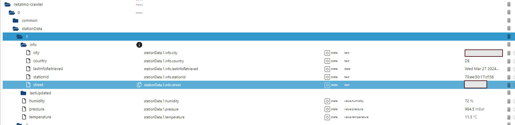
ok - die blitzer sind hier gemacht: https://forum.iobroker.net/post/512330
temperatur ist einmal ein sonoff mit messung daheim - und netatmo-crawler - adapter
das blockly ist in einem ganzen system integriert - ich schreibe alle routen in jsons um die zur abrechnung (fahrkosten) zu haben - daher nur als bild - darin wird auf eine distance von 500 meter die koordinaten in ein json gspeichert, welches dann die html datei mit den circles erzeugt
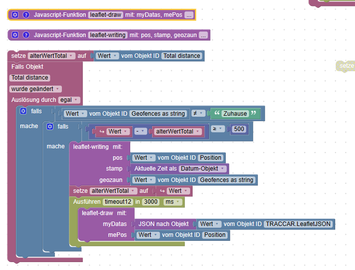
die funktion leaflet-writing schreibt ein fortlaufendes json für all dir koordinaten
die funktion leaflet-draw macht das eigentliche html file und speichert das
hier zum download - kenntwort schicke ich dir
am besten du öffnest es mit notepad++ , damit alle zeichen richtig übersetzt werden -
alles klar
mich würde insbesondere die Punkte:
Kreis, Blitzer, Temp
interssieren.Hast PN. Danke vorab.
-
alles klar
mich würde insbesondere die Punkte:
Kreis, Blitzer, Temp
interssieren.Hast PN. Danke vorab.
das beste, was ich bis jetzt gefunden habe, um text darzustellen - mit transparenten hintergrund
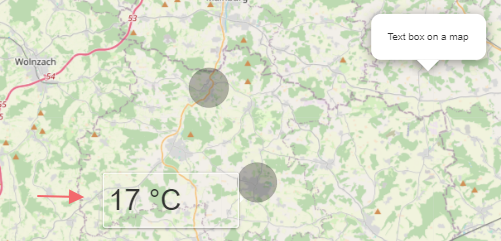
im style tag:
  .my-label {
  @charset "utf-8";
    position: absolute;
    width:150px;
    font-size:35px;
	background:transparent;
}
einbinden im script tag:
var marker = new L.marker([50.539, 11.99], { opacity: 0.01 }); //opacity may be set to zero marker.bindTooltip('17 °C', {permanent: true, className: "my-label", offset: [0, 50] }); marker.addTo(map); -
ok - die blitzer sind hier gemacht: https://forum.iobroker.net/post/512330
temperatur ist einmal ein sonoff mit messung daheim - und netatmo-crawler - adapter
das blockly ist in einem ganzen system integriert - ich schreibe alle routen in jsons um die zur abrechnung (fahrkosten) zu haben - daher nur als bild - darin wird auf eine distance von 500 meter die koordinaten in ein json gspeichert, welches dann die html datei mit den circles erzeugt
die funktion leaflet-writing schreibt ein fortlaufendes json für all dir koordinaten
die funktion leaflet-draw macht das eigentliche html file und speichert das
hier zum download - kenntwort schicke ich dir
am besten du öffnest es mit notepad++ , damit alle zeichen richtig übersetzt werden -
@liv-in-sky Mit Begeisterung lese ich grad diesen Beitrag. Könnte ich auch das Password bekommen?
da sind viele daten drin - habe ein paar geändert - das kennwort ist im chat
-
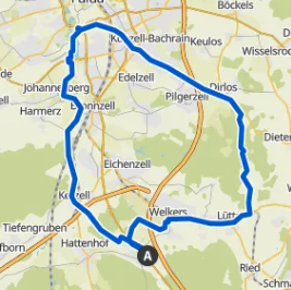
anbei Script und View.
Kannst bestimmt damit was anfangen.
Funktioniert einwandfrei.// Script um aus den DP vom Adapter "bosch-ebike" eine MAP zu erstellen und den Weg zu zeichnen // bahnuhr, 03_2024 // ############################################################################################################### // DP "javascript.0.Geräte.Fahrrad.Touren" ändert sich on({id: "javascript.0.Geräte.Fahrrad.Touren"}, function() { var body = getState("javascript.0.Geräte.Fahrrad.Touren").val; var arrTouren = []; var obj = JSON.parse(body); for (var x=0; x<= obj.length-1; x++) { var titel = obj[x].Titel; var datum = obj[x].Datum; var start = obj[x].Start; var end = obj[x].Ende; var strecke = obj[x].Strecke; var fahrzeit = obj[x].Fahrzeit; var o_trittfrequenz = obj[x].o_Trittfrequenz; var max_trittfrequenz = obj[x].max_Trittfrequenz; var o_leistung = obj[x].o_Leistung; var max_leistung = obj[x].max_Leistung; var o_speed = obj[x].o_Speed; var max_speed = obj[x].max_Speed; var bergauf = obj[x].Bergauf; var bergab = obj[x].Bergab; arrTouren.push(datum + " _ " + strecke + " km _ " + titel); } setState("javascript.0.Geräte.Fahrrad.Routen.Auswahl", JSON.stringify(arrTouren)); log (arrTouren); }); // ############################################################################################################### // DP "javascript.0.Geräte.Fahrrad.Routen.ausgewaehlt" ändert sich on({id: "javascript.0.Geräte.Fahrrad.Routen.ausgewaehlt"}, function(obj) { var arr = obj.state.val.split(" _ "); log (arr[0]); var Auswahl_Datum = arr[0]; var body = JSON.parse(getState("javascript.0.Geräte.Fahrrad.Touren").val); for (var x=0; x<20; x++) { var datum = body[x].Datum; if (datum == Auswahl_Datum) { Datei_schreiben(x+1); } } }); // ############################################################################################################### // GPS lesen und Datei html schreiben function Datei_schreiben(trip) { // Variablen var poly =""; // hier werden die GPS gespeichert var center_gps = "50.465, 9.71"; // Mittelpunkt der Karte var zoom = 13 // Zoom der Karte var pfad = "route" // Dateiname - wird in vis.0 gespeichert var logging = true; // Werte der Tour einlesen var arrTour = []; var obj2 = JSON.parse(getState("javascript.0.Geräte.Fahrrad.Touren").val); var titel = obj2[trip-1].Titel; var datum = obj2[trip-1].Datum; var start = obj2[trip-1].Start; var end = obj2[trip-1].Ende; var strecke = obj2[trip-1].Strecke; var fahrzeit = obj2[trip-1].Fahrzeit; var o_trittfrequenz = obj2[trip-1].o_Trittfrequenz; var max_trittfrequenz = obj2[trip-1].max_Trittfrequenz; var o_leistung = obj2[trip-1].o_Leistung; var max_leistung = obj2[trip-1].max_Leistung; var o_speed = obj2[trip-1].o_Speed; var max_speed = obj2[trip-1].max_Speed; var bergauf = obj2[trip-1].Bergauf; var bergab = obj2[trip-1].Bergab; arrTour.push({Titel: titel, Datum: datum, Start: start, Ende: end, Strecke: strecke, Fahrzeit: fahrzeit, o_Trittfrequenz: o_trittfrequenz, max_Trittfrequenz: max_trittfrequenz, o_Leistung: o_leistung, max_Leistung: max_leistung, o_Speed: o_speed, max_Speed: max_speed, Bergauf: bergauf, Bergab: bergab}); setState("javascript.0.Geräte.Fahrrad.Routen.ausgewaehlt_alles", JSON.stringify(arrTour)); // GPS einlesen und der Variablen poly zuweisen if (trip < 10) trip = "0" + trip; // DP bei den Objekten der eingelesen werden soll: bosch-ebike.0.trips.xx.details var obj = JSON.parse(getState("bosch-ebike.0.trips." + trip + ".details").val); var end = obj.activityData.length - 1; for (var x=0; x<=end; x++) { if (obj.activityData[x].lat > 1 && obj.activityData[x].lon > 1) { poly = poly + "["+obj.activityData[x].lat+", "+obj.activityData[x].lon+"]" if (x < end) poly = poly + "," } } if (logging) log (poly); // html erzeugen und speichern in /vis.0/xxx.html var string = '<!DOCTYPE html>\n<html>\n<head>\n<title>Simple Leaflet Map</title>\n<meta charset="utf-8" />\n' string = string + '<link rel="stylesheet" href="https://unpkg.com/leaflet@1.6.0/dist/leaflet.css"integrity="sha512-xwE/Az9zrjBIphAcBb3F6JVqxf46+CDLwfLMHloNu6KEQCAWi6HcDUbeOfBIptF7tcCzusKFjFw2yuvEpDL9wQ=="crossorigin=""/></head>\n' string = string + '<body>\n<div id="map" style="width: 980px; height: 530px"></div>\n<script src="https://unpkg.com/leaflet@1.6.0/dist/leaflet.js"integrity="sha512-gZwIG9x3wUXg2hdXF6+rVkLF/0Vi9U8D2Ntg4Ga5I5BZpVkVxlJWbSQtXPSiUTtC0TjtGOmxa1AJPuV0CPthew=="crossorigin=""></script>\n<script>\n' string = string + "var map = L.map('map').setView([" + center_gps + "], " + zoom + ");\n" string = string + "mapLink = '<a href=" + '"http://openstreetmap.org"' + ">OpenStreetMap</a>';\n" string = string + "L.tileLayer( 'http://{s}.tile.openstreetmap.org/{z}/{x}/{y}.png', {attribution: '© ' + mapLink + ' Contributors', maxZoom: 18,}).addTo(map);\n" string = string + 'var polyline = L.polyline([ \n' + poly + '\n], { color: "blue", weight: 3, opacity: .7, lineJoin: "round" } ).addTo(map);\n' string = string + '</script>\n</body>\n</html>' writeFile("vis.0", "/Routen/" + pfad + trip +".html", string, (error) => { if (logging) log('Datei "route.html" gespeichert!'); }); setState("javascript.0.Geräte.Fahrrad.Routen.Datei","/vis.0/Routen/" + pfad + trip + ".html"); }View:
Hi,
ich habe heute endlich den Bosch-ebike-Adapter zum Laufen bekommen.
Danach wollte ich auf deine Erfahrungen zurückgreifen und habe dein Script und die View importiert.
Das bekomme ich leider nicht zum Laufen, ich denke, da fehlt irgend etwas.
Wie werden die Objekte/Variablen unter javascript.0 gefüllt?
Ich denke, irgend etwas fehlt mir auch in der View? -
Hi,
ich habe heute endlich den Bosch-ebike-Adapter zum Laufen bekommen.
Danach wollte ich auf deine Erfahrungen zurückgreifen und habe dein Script und die View importiert.
Das bekomme ich leider nicht zum Laufen, ich denke, da fehlt irgend etwas.
Wie werden die Objekte/Variablen unter javascript.0 gefüllt?
Ich denke, irgend etwas fehlt mir auch in der View?@kanumouse
Da fehlt gar nix.
Läuft einwandfrei.Bitte alles genau anschauen und versuchen zu verstehen..
-
@kanumouse
Da fehlt gar nix.
Läuft einwandfrei.Bitte alles genau anschauen und versuchen zu verstehen..
-
@bahnuhr
Ich habe mir schon den Kopf zerbrochen, komme aber leider nicht weiter.
Du hast sicherlich recht, dass ich irgend etwas nicht verstehe.@bahnuhr
Hast du vielleicht einen Tipp für mich?
Wenn ich das richtig verstehe, ist mir nicht klar wie die javascript.0.Geräte.Fahrrad.Touren-Variable als JSON gefüllt wird???
Ich weiß nicht, wie die Daten der Trips aus der ebike-Instanz als Ausgangsdaten für den Script verwendet werden, sehe ich offensichtlich nicht durch. -
@bahnuhr
Hast du vielleicht einen Tipp für mich?
Wenn ich das richtig verstehe, ist mir nicht klar wie die javascript.0.Geräte.Fahrrad.Touren-Variable als JSON gefüllt wird???
Ich weiß nicht, wie die Daten der Trips aus der ebike-Instanz als Ausgangsdaten für den Script verwendet werden, sehe ich offensichtlich nicht durch.@kanumouse sagte in maps mit Streckendarstellung:
ist mir nicht klar wie die javascript.0.Geräte.Fahrrad.Touren-Variable als JSON gefüllt wird???
Das ist nicht wichtig, bzw. bei jedem ja anders.
Du musst selber wissen wo deine lat und lon liegen.
Und diese musst du dann per script poly zuweisen.
Um danach eine html zu erzeugen.// GPS einlesen und der Variablen poly zuweisen if (trip < 10) trip = "0" + trip; // DP bei den Objekten der eingelesen werden soll: bosch-ebike.0.trips.xx.details var obj = JSON.parse(getState("bosch-ebike.0.trips." + trip + ".details").val); var end = obj.activityData.length - 1; for (var x=0; x<=end; x++) { if (obj.activityData[x].lat > 1 && obj.activityData[x].lon > 1) { poly = poly + "["+obj.activityData[x].lat+", "+obj.activityData[x].lon+"]" if (x < end) poly = poly + "," } } if (logging) log (poly); // html erzeugen und speichern in /vis.0/xxx.html var string = '<!DOCTYPE html>\n<html>\n<head>\n<title>Simple Leaflet Map</title>\n<meta charset="utf-8" />\n' string = string + '<link rel="stylesheet" href="https://unpkg.com/leaflet@1.6.0/dist/leaflet.css"integrity="sha512-xwE/Az9zrjBIphAcBb3F6JVqxf46+CDLwfLMHloNu6KEQCAWi6HcDUbeOfBIptF7tcCzusKFjFw2yuvEpDL9wQ=="crossorigin=""/></head>\n' string = string + '<body>\n<div id="map" style="width: 980px; height: 530px"></div>\n<script src="https://unpkg.com/leaflet@1.6.0/dist/leaflet.js"integrity="sha512-gZwIG9x3wUXg2hdXF6+rVkLF/0Vi9U8D2Ntg4Ga5I5BZpVkVxlJWbSQtXPSiUTtC0TjtGOmxa1AJPuV0CPthew=="crossorigin=""></script>\n<script>\n' string = string + "var map = L.map('map').setView([" + center_gps + "], " + zoom + ");\n" string = string + "mapLink = '<a href=" + '"http://openstreetmap.org"' + ">OpenStreetMap</a>';\n" string = string + "L.tileLayer( 'http://{s}.tile.openstreetmap.org/{z}/{x}/{y}.png', {attribution: '© ' + mapLink + ' Contributors', maxZoom: 18,}).addTo(map);\n" string = string + 'var polyline = L.polyline([ \n' + poly + '\n], { color: "blue", weight: 3, opacity: .7, lineJoin: "round" } ).addTo(map);\n' string = string + '</script>\n</body>\n</html>' writeFile("vis.0", "/Routen/" + pfad + trip +".html", string, (error) => { if (logging) log('Datei "route.html" gespeichert!'); }); setState("javascript.0.Geräte.Fahrrad.Routen.Datei","/vis.0/Routen/" + pfad + trip + ".html"); -
@kanumouse sagte in maps mit Streckendarstellung:
ist mir nicht klar wie die javascript.0.Geräte.Fahrrad.Touren-Variable als JSON gefüllt wird???
Das ist nicht wichtig, bzw. bei jedem ja anders.
Du musst selber wissen wo deine lat und lon liegen.
Und diese musst du dann per script poly zuweisen.
Um danach eine html zu erzeugen.// GPS einlesen und der Variablen poly zuweisen if (trip < 10) trip = "0" + trip; // DP bei den Objekten der eingelesen werden soll: bosch-ebike.0.trips.xx.details var obj = JSON.parse(getState("bosch-ebike.0.trips." + trip + ".details").val); var end = obj.activityData.length - 1; for (var x=0; x<=end; x++) { if (obj.activityData[x].lat > 1 && obj.activityData[x].lon > 1) { poly = poly + "["+obj.activityData[x].lat+", "+obj.activityData[x].lon+"]" if (x < end) poly = poly + "," } } if (logging) log (poly); // html erzeugen und speichern in /vis.0/xxx.html var string = '<!DOCTYPE html>\n<html>\n<head>\n<title>Simple Leaflet Map</title>\n<meta charset="utf-8" />\n' string = string + '<link rel="stylesheet" href="https://unpkg.com/leaflet@1.6.0/dist/leaflet.css"integrity="sha512-xwE/Az9zrjBIphAcBb3F6JVqxf46+CDLwfLMHloNu6KEQCAWi6HcDUbeOfBIptF7tcCzusKFjFw2yuvEpDL9wQ=="crossorigin=""/></head>\n' string = string + '<body>\n<div id="map" style="width: 980px; height: 530px"></div>\n<script src="https://unpkg.com/leaflet@1.6.0/dist/leaflet.js"integrity="sha512-gZwIG9x3wUXg2hdXF6+rVkLF/0Vi9U8D2Ntg4Ga5I5BZpVkVxlJWbSQtXPSiUTtC0TjtGOmxa1AJPuV0CPthew=="crossorigin=""></script>\n<script>\n' string = string + "var map = L.map('map').setView([" + center_gps + "], " + zoom + ");\n" string = string + "mapLink = '<a href=" + '"http://openstreetmap.org"' + ">OpenStreetMap</a>';\n" string = string + "L.tileLayer( 'http://{s}.tile.openstreetmap.org/{z}/{x}/{y}.png', {attribution: '© ' + mapLink + ' Contributors', maxZoom: 18,}).addTo(map);\n" string = string + 'var polyline = L.polyline([ \n' + poly + '\n], { color: "blue", weight: 3, opacity: .7, lineJoin: "round" } ).addTo(map);\n' string = string + '</script>\n</body>\n</html>' writeFile("vis.0", "/Routen/" + pfad + trip +".html", string, (error) => { if (logging) log('Datei "route.html" gespeichert!'); }); setState("javascript.0.Geräte.Fahrrad.Routen.Datei","/vis.0/Routen/" + pfad + trip + ".html");@bahnuhr
Danke für den Hinweis.
Aber jetzt bin ich richtig verwirrt und ich glaube zu blöd dazu.
Meine lat und lon habe ich in deinem Script an meinem Standort angepasst. Aber mit dem Rest bin ich überfordert, da sich meine AKenntnisse in der Programmierung im Anfangstadium befinden. -
@kanumouse sagte in maps mit Streckendarstellung:
ist mir nicht klar wie die javascript.0.Geräte.Fahrrad.Touren-Variable als JSON gefüllt wird???
Das ist nicht wichtig, bzw. bei jedem ja anders.
Du musst selber wissen wo deine lat und lon liegen.
Und diese musst du dann per script poly zuweisen.
Um danach eine html zu erzeugen.// GPS einlesen und der Variablen poly zuweisen if (trip < 10) trip = "0" + trip; // DP bei den Objekten der eingelesen werden soll: bosch-ebike.0.trips.xx.details var obj = JSON.parse(getState("bosch-ebike.0.trips." + trip + ".details").val); var end = obj.activityData.length - 1; for (var x=0; x<=end; x++) { if (obj.activityData[x].lat > 1 && obj.activityData[x].lon > 1) { poly = poly + "["+obj.activityData[x].lat+", "+obj.activityData[x].lon+"]" if (x < end) poly = poly + "," } } if (logging) log (poly); // html erzeugen und speichern in /vis.0/xxx.html var string = '<!DOCTYPE html>\n<html>\n<head>\n<title>Simple Leaflet Map</title>\n<meta charset="utf-8" />\n' string = string + '<link rel="stylesheet" href="https://unpkg.com/leaflet@1.6.0/dist/leaflet.css"integrity="sha512-xwE/Az9zrjBIphAcBb3F6JVqxf46+CDLwfLMHloNu6KEQCAWi6HcDUbeOfBIptF7tcCzusKFjFw2yuvEpDL9wQ=="crossorigin=""/></head>\n' string = string + '<body>\n<div id="map" style="width: 980px; height: 530px"></div>\n<script src="https://unpkg.com/leaflet@1.6.0/dist/leaflet.js"integrity="sha512-gZwIG9x3wUXg2hdXF6+rVkLF/0Vi9U8D2Ntg4Ga5I5BZpVkVxlJWbSQtXPSiUTtC0TjtGOmxa1AJPuV0CPthew=="crossorigin=""></script>\n<script>\n' string = string + "var map = L.map('map').setView([" + center_gps + "], " + zoom + ");\n" string = string + "mapLink = '<a href=" + '"http://openstreetmap.org"' + ">OpenStreetMap</a>';\n" string = string + "L.tileLayer( 'http://{s}.tile.openstreetmap.org/{z}/{x}/{y}.png', {attribution: '© ' + mapLink + ' Contributors', maxZoom: 18,}).addTo(map);\n" string = string + 'var polyline = L.polyline([ \n' + poly + '\n], { color: "blue", weight: 3, opacity: .7, lineJoin: "round" } ).addTo(map);\n' string = string + '</script>\n</body>\n</html>' writeFile("vis.0", "/Routen/" + pfad + trip +".html", string, (error) => { if (logging) log('Datei "route.html" gespeichert!'); }); setState("javascript.0.Geräte.Fahrrad.Routen.Datei","/vis.0/Routen/" + pfad + trip + ".html");

Hello! It looks like you're interested in this conversation, but you don't have an account yet.
Getting fed up of having to scroll through the same posts each visit? When you register for an account, you'll always come back to exactly where you were before, and choose to be notified of new replies (either via email, or push notification). You'll also be able to save bookmarks and upvote posts to show your appreciation to other community members.
With your input, this post could be even better 💗
Register LoginSupport us
245
Online32.7k
Users82.6k
Topics1.3m
Posts